FLC115
Current watches, warnings, and advisories for Sarasota County (FLC115) FL
Rip Current Statement issued March 15 at 5:35PM EDT until March 17 at 8:00PM EDT by NWS Tampa Bay Ruskin FL
* WHAT...
Dangerous rip currents expected.* WHERE...
Pinellas, Coastal Hillsborough, Coastal Manatee,Coastal Sarasota, Coastal Charlotte and Coastal Lee Counties.* WHEN...
From Monday afternoon through Tuesday evening.* IMPACTS...
Rip currents can sweep even the best swimmers awayfrom shore into deeper water.
Rip Current Statement
****************
| KB4P Weather | |||
|---|---|---|---|
| LAST READING AT TIME: 10:30 PM DATE: March 16 2026, time of next update: 10:40 pm | |||
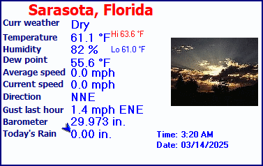
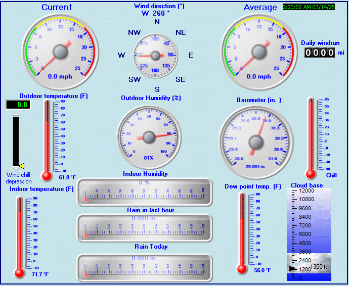
| Current Weather | Night time/Dry | Current Temperature | 68.5°F (20.3°C) (Heat Index 68.5°F ), Apparent temp 70.6°F |
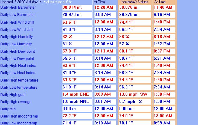
| Maximum Temperature (since midnight) | 83.8°F at: 2:07 PM | Minimum Temperature (since midnight) | 68.2°F at: 10:26 PM |
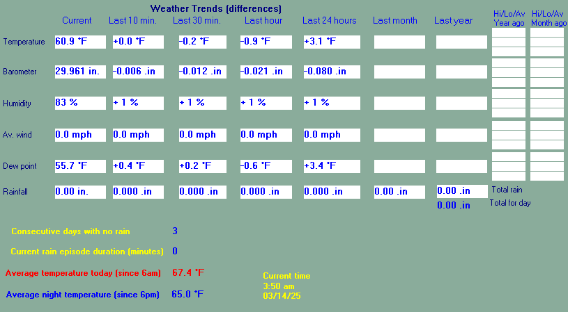
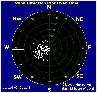
| Average windspeed (ten minute) | 2.8 mph | Wind Direction (ten minute) | NNW (328°) |
| Windchill Temperature | 68.5°F | Maximum Gust (last hour) | 10.4 mph at: 10:16 PM |
| Maximum Gust (since midnight) | 26.5 mph at: 11:34 AM | Maximum 1 minute average (since midnight) | 14.7 mph at: 12:24 PM |
| Rainfall (last hour) | 0.00 in. (0.0 mm) | Rainfall (since midnight) | 0.15 in. (3.8 mm) at 8:37 PM |
| Rainfall This month | 1.33 in. (33.8 mm) | Rainfall To date this year | 3.38 in. (85.9 mm) |
| Maximum rain per minute (last hour) | 0.00 in/min | Maximum rain per hour (last 6 hours) | 0.07 in/hour |
| Yesterdays rainfall | 0.51 in | DewPoint | 61.4°F (Wet Bulb :64.2°F ) |
| Humidity | 78 %, Humidex 77.2°F | Barometer corrected to msl | 29.929 in. (1013.5 hPa) |
| Pressure change | +0.04 in. (last hour) | Trend (last hour) | RISING SLOWLY |
| Pressure change (last 12 hours) | +0.09 in | Pressure change (last 6 hours) | +0.12 in |
Use the RELOAD facility on your browser to retrieve the latest data.